Wednesday 27 January 2016

Te Araroa : Wellington to Havelock

KM this section : 84
KM completed : 1770

On the ferry.
I could spend longer in Wellington, there is plenty going on, but South Island calls, and I have a busy day ahead.  Firstly the three hour inter island ferry, which is really no different from the familiar English Channel experience - albeit with rather better views as we sail through the Queen Charlotte Sound towards Picton.  One thing, do foot passengers need to check in luggage when crossing the channel?  Well, I manage to keep my bag, once again good that it is small, but have to surrender my poles.  Turns out to be a bad idea - they emerge from the baggage carousel at the other end bent and broken, oops.  This would happen when I have another boat to catch from across the harbour in - quick watch check - thirty minutes...

Ship Cove.
OK, I phone the water taxi people, as long as I get there for 1:30pm it's good.  Duty manager at the ferry port is apologetic, offers me a new looking carbon fibre(!) pole from lost property plus fifty dollars compensation there and then.  Five minutes walk to the other boat, and there is a sports shop over the road, one new pole, much like my old ones (except, you know, not knackered) for forty-five dollars.  Profit!  Could have been much worse... The water taxi turns out to be the mail run up the sound, interesting as we get a commentary on the various bird refuges and so forth, plus the people who have paid sometimes millions of dollars for houses only accessible by boat.  Then they get tourists filming them when they collect their mail...

With a weka.
After a couple of hours I am dropped off at Ship Cove, this is where Captain Cook first set foot on New Zealand soil, liked the place so much he came back four times.  Well, it does seem rather nice... the landscape here was impressive from sea level, but from the path it is something else again.  The Queen Charlotte Track as it's called follows a narrow spit of land, affording incredible views to either side of the Marlborough sounds - river valleys long since drowned as the sea rose.  What's more I can appreciate the view as I walk on a nicely formed cycle track, hopefully this is how South Island will be.  There is even a little resort thirteen kilometres or so in, where I celebrate with some rather fine food.  Don't make it much further for some reason.

The whole track was like this...
The guide on the water taxi had warned us about thieving wekas, to be honest I assumed this was Kiwi humour.  But no, next morning as I'm packing up the tent a flightless bird is approaching my tent pegs with an inquisitive, indeed acquisitive eye.  Later one even grabs my boot by the lace and tries to drag it off... all part off the South Island experience, which so far is all good.  New poles are good, so are the new shoes, and the track is fantastic, I take many photos and don't want to stop walking, making nearly fifty kilometres on my second day here.  Well, the first was an easy one in terms of walking, what with most of the day on boats it was practically a zero.

Speaking of zero days, I did plan to have one at Pelaros Bridge, forty kilometres or so on, but there is really nothing there other than a cafe and campsite, so I go for two easy days instead, twenty kilometres to Havelock then.  Nice place, I get a bed, beer and burger - plus a sewing kit, one of my rucksack zips, and a trouser pocket need work.  The pocket, I rarely use, so it looks like I've worn the thread away from the inside purely through walking!

Photos to go with this post can be found here.

Sunday 24 January 2016

Te Araroa : Waikanae to Wellington

KM this section : 81
KM completed : 1686

Colonial Knob summit.  No sniggering please.
The two German lads from the hut a day or so back are going to hitch into Wellington, all road from here apparently.  Well I reckon they missed out...  From Waikanae there is a pleasant (Flat!  Dry!) river walk, then a well built scenic path through wetland, and a bit of beach.  Then yes, we have a number of kilometres along the centennial highway, but there's a pedestrian walkway, and with the traffic to one side and the waves to the other I think it's rather cool.  Before long the walkway departs a little from the road anyway, but remains easy walking until my camp for the day, the ah, heavenly, Mana.  Well, it is nice, a fine pub where I have schnitzel for a change (so much meat) and a free campsite - rather cool just a little way from the capital.

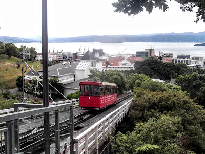
The Wellington Cable Car.
Shockingly, the walk to Wellington from here is lovely, a climb on well made paths, and actual grassy ridges, over a couple of big hills, Colonial Knob and Mount Kaukau.  I'm in a hall of residence again, is nice, not quite sure about the city mind you, seems to have many hipsters who want to sell me expensive craft beer.  I at least get a cheap, good, Pad Thai - Pad Thai really should be cheap.

One last bit of North Island, I'm having a lazy day, the pack is almost empty and it's just ten kilometres to the last bit of route - though I will have to walk back.  But, as I walk I don't seem to be making much progress.  Eventually I realise they have changed the route, my idea of the distance comes from the PDF map file I downloaded, but the signs are taking me a different way entirely, and the GPX line agrees with them.  Amusingly, it is close to the scenic return route I'd planned, though with extra bits to take in more of the high points around Wellington - a city so hilly that some residents have private cable cars to get to their homes.  Well, I make it to the end, incongruously set in a small children's playground, I have to move it though as I absolutely must buy new shoes, the current pair (thirty dollars from The Warehouse) are in pieces after just three hundred kilometres or so.  In defence of my cheapskate ways, the similarly priced pair from Decathlon back in London lasted fourteen hundred kilometres.  Anyway... fortunately there is a dead straight road back to town, where I do indeed acquire shoes, plus of course beer.  South Island tomorrow!

More new shoes!
Photos to go with this post can be found here.
Te Araroa : Levin to Waikanae

KM this section : 74
KM completed : 1605

Hiding from the rain, in a hut.
I have a good rest in Levin, plenty of food and beer, I do feel a bit of a pall hanging over me though, truth is I am dreading the next section.  The guide is not encouraging about the Tararua range, suggesting a mere fifty-two kilometres could take six days.  Phrases include 'extreme weather' and 'be prepared to wait out storms'.  It doesn't mention the route on the ground being twice the length of that on the map, or that it will consist of kilometre after kilometre of mud, but I have my suspicions.  Can it really be that bad?

In a word, yes.  This is the worst walking since that first bit of bush way back in Northland, it is truly awful, I manage that fifty-two kilometres in three days including one 'twelve kilometre' day, haha, but it is three days of misery.  The sad fact is, this will be my take away memory of North Island.  Not the beaches, or the alpine crossing, or even the kayak, but rather the day after day of terrible, terrible 'paths' that simply aren't fit to walk on.  I find myself wondering why the trail comes to these awful places, surely there must be better walking here?  One clue is the signs telling us what a 'privilege' it is whenever we cross private land - right to roam never happened here I fear.  And I guess the DOC just love their bush - maybe conservation isn't always the best fit with trail management.  It's a shame... as I write in a hut log book, hopefully South Island will be better.

So much horrible mud, so much.
Speaking of which, I do at least get to spend a couple of nights in huts, which is... different.  Hell, it is a bed, and shelter, who needs privacy.  Nice to see Transient again, interesting chap, a veteran of the Appalachian Trail and PCT, he has plenty of tales for the hut.  I'm most impressed that as well as keeping pace with me, he is also researching for a guide which will cover things like stores and accommodation in a way the official guide frankly, does not.  More power to his elbow.

It is such a relief to walk on my ruined shoes into Waikanae - sadly, short for 'Waikanae not find a pub here?'  Oh, there was one but we demolished it.  Stupid country.  Well, the campsite is five kilometres past town anyway... and what is another three kilometres further to a pub?  Wish they hadn't told me it was a fifteen minute walk, but whatever.

Bless you your lordship, we're not worthy of the privilege of walking on your land, blimey, strike a light guvnor.
Photos to go with this post can be found here.

Sunday 17 January 2016

Te Araroa : Wanganui to Levin

KM this section : 165
KM completed : 1531

On the beach, just past Koitiata.
After taking a day longer than planned with the kayak thing, I'm minded to keep walking without a break for a while - I mean, I was just sitting down for the last few days.  And the holiday park is nice enough, but at least six kilometres out of town so hardly handy for shopping and so forth.  But, in the event I feel a bit broken as I walk into the city, and passing a nice looking motel it is just too tempting.  Works out well in the event, I wander Wanganui sans pack, buy some new pole ends, walking shoes and of course food, and see the sights.  Seems a nice place, I like the regional museum which has giant moa skeletons, stone axe heads looking just like those from neolithic Europe but just a century or two old, and an amazing seventy seater war canoe.  Of course there is also a pub, time for the usual massive burger then.

Pun-tastic Bulls.
From here, the route involves a few days of pretty dull road walking through what is, for NZ, a populous region.  I visit the towns of Bulls and Feilding and the city of Palmerston North, I could probably speed up here but camping would be tricky, as it is I have pleasant stops at Koitiata (free camping for TA trampers!), Mount Lees (a B&B for a change - luxury and home cooked food!), and Palmerston North (cheap food from Pak'nSave).  The section alongside a busy highway isn't ideal, there have been a few of these where I'm pretty sure a better if slightly longer route could be found along minor roads - perhaps they just think people will hitch-hike?

I at least get to leave the roads for the last seventy kilometres or so before Levin... am I pleased to see the bush?  Not really.  There is of course a bit where the (signed, clearly correct) track on the ground deviates massively from the line on the official map, adding maybe three kilometres.  The day after features some foul mud, the new shoes keep it out pretty well, but their soles are disintegrating, I've lost a pole end too, the Wanganui purchases not going so well.  I do achieve something though, fifteen hundred kilometres done.  Is it halfway?  Hard to say, given how unrelated to reality the official distances are... still, getting there.  Levin is nine kilometres off the route, but I need a rest, and to shop, and of course eat beef.  Why, double up on the burger and bacon you say, don't mind if I do.

Most artistic.
Photos to go with this post can be found here.

Te Araroa : Raetihi to Wanganui

KM this section : 118
KM completed : 1366

So, I get the tent up at Raetihi - pole still behaving - and notice plenty of canoes around.  Why yes they do hire them, all booked up though.  Dammit, I am not giving up on this.  The guide makes it clear this is one of the highlights of the trip, I even wrote to my niece that I'd be doing it... all I need to find is a company willing to take a boat to Pipiriki for me.  And in fact the second I call will... not loving the two hundred and fifty dollars cost but what can you do.  Of course they say, you can join a group that left Whakahoro yesterday, so if I'd got any signal... Sigh.  I can at least paddle for eighty kilometres or so down to Wanganui the city (no 'h' - yes they are talking about changing it).

Just keep it pointing downstream, easy.
Well, the walk to Pipiriki is easy enough, good thing as the canoe company want me there at 2pm to take charge of what turns out to be a kayak.  Well, given it is chucking it down I am happy to not be walking in the afternoon.  Next day I 'portage', or carry the kayak down to the river - it is very heavy - and stuff my things into the supplied drybags, including my socks and zip-off trouser legs, I am expecting to get wet here.  In fact I get into the boat and move off without trouble, except that a veritable swarm of midges has turned up to feast on my exposed legs.  I frantically paddle towards the middle of the river, simultaneously slapping at the horrid things, eventually most seem to have gone, either squashed or sated, I itch like hell though.  Hmm, was supposed to join a group wasn't I?  To be honest, the guy who gave me the kayak wasn't sure when they'd arrive, or even that they were expecting me, so screw it.

Me, in a kayak, on the river.
Paddling along proves easy - it's twenty years since I was last in a kayak, but I recall it being simple enough.  What rapids there are don't trouble me, it is hardly white water, and I even manage to park the thing and put my legs back on.  This is rather fun I must say, the perspective on the landscape is new, and the Whanganui gorge is certainly impressive.  I could consider a longer trip in one of these.  This is supposed to take three days, according to both guide and hire firm.  Predictably I'm approaching halfway by 4pm, I reckon with an early start you could do it in a day.  Instead I camp by a nice little beach and proceed to build a large fire.  An Italian girl I met at Whakahoro paddles by, seems she found the two Americans she was joining there, and indeed a Canadian.  They're travelling at a more relaxed pace than me, still hike your own hike and all.  No sign of the big group I was meant to join.

Not the most accessible campsite ever.
The paddle goes well the next day too, must say it is nice not to have my pack on - light as it is after a long day the straps start to cut into me.  The morning flies by, soon enough I've only got ten kilometres to go, the only difficulty a section where a strong headwind made progress difficult.  I spot the group from yesterday moored up, really should say hi.  Except... how, and indeed why, did they moor here?  The riverbank slopes at about forty-five degrees, getting a foot on dry land is tricky, I just manage it then spot my paddle floating away, oops.  Step back on the kayak to grab it and, double oops, the boat capsizes and I'm in the river.  Joy.  They helpfully tie the thing up while I dry out, but that causes trouble too... stupidly I try sitting in the kayak when it's time to leave, but that makes it slide down the slope, the rope is too taut to untie, and the front of my boat is filling with water...

I get going in the end, but the thing is not the same, paddling forward it won't go in a straight line.  Of course this is because the front luggage compartment is full of water... OK, I manage to progress by turning the kayak around and paddling backwards, this gets me as far as a proper mooring where I can sort things out.  I catch the group up just before we reach Wanganui holiday park, time to get the tent up, find some beer and fish and chips.  My fellow hikers are going to camp on a Maori family's lawn, apparently this will be free.  Again, HYOH.

Photos to go with this post can be found here.

Sunday 10 January 2016

Te Araroa : National Park Village to Raetihi

KM this section : 89
KM completed : 1248

Horse sculpture on the way down to Whakahoro.
I certainly picked a good time to take a day off at National Park, as it rains pretty much all day.  At least it stops in time for me to head for Eivin's for dinner and beer - they seem to be giving me discounts too, could get used to this.  From here it's a long but easy walk downhill to Whakahoro on the Whanganui river, I've planned two days for this, but the going is so good that I make it in one, fifty-two kilometres, a new personal best I think.  There is even a cafe open at the end, at nearly 7pm this is a shock, but a cheese and ham toastie goes down very well.

From here I continue on the 'mountains to sea cycle trail', still easy going then, albeit with a six hundred metre ascent before heading back to the river.  Interesting though, this valley is where forty or so first world war veterans were settled, each with their own little parcel of land.  In the end, wresting a living from this isolated, steeply sloped gorge proved too much, and now there is little sign the men and their families were ever here.  As a sort of memorial, near the valley bottom is the impressive 'bridge to nowhere', a substantial concrete structure spanning the Mangapurua stream, with little more than a dirt track on either side.

Camped by the river.
Past the bridge, it's a short distance back to the Whanganui, I'm expecting to find a campsite here, and indeed I spot tents below me... but the path keeps going, still a long way above the water.  OK, maybe it doubles back... I walk on, eventually have the sense to check the GPS, oops - I'm a good four hundred metres away from the route.  Back I go, to where the path diverges from the GPX line, nothing.  Back upstream, check the map, no good... dammit, I can see people camped, so I yell at them, apparently I should keep on upstream.  A bit worrying that the camp seems to be on the other side of the river, but what can you do.  And they're right, in a new low for the official map, I walk fully five hundred metres further upstream before the path doubles back to the riverside, where there is, pretty much, nothing.

The Bridge to Nowhere.
The campsite is indeed on the far bank, here there is a sign explaining the history of the valley and not much else.  OK, the guide says this is a dead end for walkers, but I'd expected more than this.  Sigh.  The idea is that you get a canoe from here, however while I did try, no company seemed interested in bringing a canoe to this isolated spot for me.  Other trampers I've spoken to were skipping sections of the walk to get around this, e.g. by getting a canoe from Whakahoro, this is not for me.  So, I camp on a tiny patch of grass by the riverside, say hi to James and Mary-Kate when they paddle up the next morning, and walk back the way I came.  OK... I will phone from the high point of the track back towards Whakahoro, there was signal there yesterday... but today of course, there isn't.  Well I'm not carrying on walking north on the off chance of getting a canoe, so instead I detour off the route, taking the alternative 'mountains to sea' track via Raetihi.  Which proves a pleasant enough place, the same grid pattern and frontier town atmosphere as National Park.  I've walked around sixty additional kilometres from when I started backtracking, and still have thirty or so to go before rejoining the route, but what can you do.  For what it's worth, I'm aware of at least twenty hikers doing this section around now, and not one has done it the way the guide wants.

Totally worth walking to Raetihi for.
Photos to go with this post can be found here.

Saturday 2 January 2016

Te Araroa : Taumarunui to National Park Village

KM this section : 111
KM completed 1159

Camped by the 42 Traverse.
Taumarunui seems a little better the next day, at least I manage to get some shopping done, much food, a pie of course, and stuff to work on my troublesome tent pole - a hacksaw, some duct tape, it's as good as new.  For my second night at the campsite I upgrade to a cabin, real bed at last, and also make use of the BBQ - cooking and eating four cheeseburgers, one after another.  I don't think it too many.

I've planned short distances for the next couple of days, the route is mainly off road and remains 'alpine'.  But in fact, the '42 traverse' cycle track proves absurdly easy walking, on my first day I keep going 'til 6pm, at which point I'm at least six kilometres past my planned stop.  It's so nice that the next day I do a bit extra... in the sense of, miss the (unsigned) turn from the traverse and go three kilometres the wrong way.  Ho hum... well, it isn't just me, returning to the trail I meet a French chap who has done the same thing.  He's going by the trail name of Moonkid, and somewhat to my surprise asks if I'm Tim. Well, guilty... turns out some Americans, having read my entries in the log books of the various huts recently passed, were asking after me.  Suspect it is a bit of a disappointment when they finally meet me at around 5pm.

Emerald Lakes.
We reach a campsite together shortly after, it seems lazy to stop now, and indeed they're going to keep going.  I decide to call it a day though, I may still be sleeping in the tent but at least I can sit in the TV room for a bit first.  Until it turns out to contain a massive cockroach anyway.  Moonkid is here too, he has the same tent as me - and has had to buy a new pole for it.

From here I walk through a real highlight of the route, the Tongariro Alpine Crossing.  This involves an ascent of around a thousand metres, mostly up a well made path with magnificent views towards Lake Taupo.  I then make my way through an incredible volcanic landscape, there are lakes of brilliant blue and green - not for drinking thanks to the high mineral content - steaming vents, a mighty red crater, and looming above, the brooding dark cone of Mount Ngauruhoe, made famous as Mount Doom in the LOTR films.  I am slightly ashamed that I don't get to the top... it's a three hour detour off route, would likely mean walking until well past 9pm, as it is I get to Whakapapa for 6.30pm, time for beer... maybe.  The place has three licensed establishments according to my research, first up, a pub called the Tussock, is shut.  Well it is New Year's Day, what am I thinking.  Strike one.  The imposing Chateau Tongariro is open, but the girl there looks at me and says, dinner for residents only.  Hmm.  Strike two.  Thankfully, the Skotel (this being a ski resort) comes through, and I get a pizza with, it seems, the cured product of an entire pig on it.  Also pretty sure they give me several free beers, which is nice.

It's a short walk the next day to National Park Village, and a zero day next as well, I am so lazy.  Well, a chance to pile on some calories before continuing.  Odd little place, again a ski resort, given the lifts aren't here I guess it caters for those on a budget.  Works for me anyway, beer and food are available.

Me and Mount Ngauruhoe.
Photos to go with this post can be found here.