Thursday, 28 September 2017

Pacific Crest Trail : Cascade Locks to White Pass

Miles this section : 148
Miles completed : 2292

PCT beer courtesy of Geared Up.
Washington seems pretty much like Oregon at first, more green tunnel with occasional glimpses of the world outside as I walk up past Table Mountain - Mount Adams dominates the northern horizon, and I can make out Rainier too.  The Cascades seem to be characterised by isolated giants, rather than the crowd standing shoulder to shoulder that is the Sierras.  I follow the trail up to over five thousand feet, walking along undulating ridges, Washington is not as flat as Oregon, though like the previous state it does have some level sections with many lakes, old lava fields maybe.  It is very green here, thick undergrowth carpets the forest floor, probably due to a different climate - it's supposed to rain a fair bit, but no sign of that yet, it is still pretty hot in fact.

A view of Mount St. Helens.
I enjoy a day of so much trail magic, firstly courtesy of Geared Up at 9:30am, he has tacos, and also champagne?  Well why not.  Beer ensues, this all takes a couple of hours, then Bliss says his wife will have trail magic too, ten miles or so further on, an incentive to get moving and in fact I get there for 4:30, there's more beer, chilli dogs, cake, and food to take away - fresh bread!  Somehow I manage a twenty mile day despite all this.  Of course I need to do slightly longer days now, but OK, without much food in my pack I can manage twenty-five mile days, helps to have encouragement from some familiar faces on the trail, from Cascade Locks and earlier.  There's more free food too, huckleberries fresh from the bush, most tasty.

Repairing the tent.
I'm packing up the tent with a day and half to go until my next stop, White Pass, when the elastic shock cord holding one of my tent poles together snaps, oops, well, I leave fixing it until the afternoon, it's a fiddly job, I have to sacrifice another bit of my pack, a bit of shock cord from the top intended to allow stuff to be attached there.  This takes me an hour, leaving me a little short on time, not ideal as the trail now heads into the Goat Rocks, much climbing is involved and indeed this section includes the high point of the trail in Washington.  It's a beautiful walk along a high rocky ridge, the air is very smoky though, only the nearby slopes are visible, beyond them are dark shapes in a grey void, all lit by a red sun.  I make it to camp for 8pm, there's just enough light to pitch the tent, the nights are drawing in.  From here it's just an easy morning's walk down to White Pass, where as I often do I get a burrito for lunch, then busy myself with a shower and laundry.  News here is that seventy miles of trail are closed to the north... I will find a way.

The rather splendid Goat Rocks Wilderness.
Photos to go with this post can be found here.

Tuesday, 12 September 2017

Pacific Crest Trail : Cascade Locks Interlude

Miles this section : 0
Miles completed : 2144

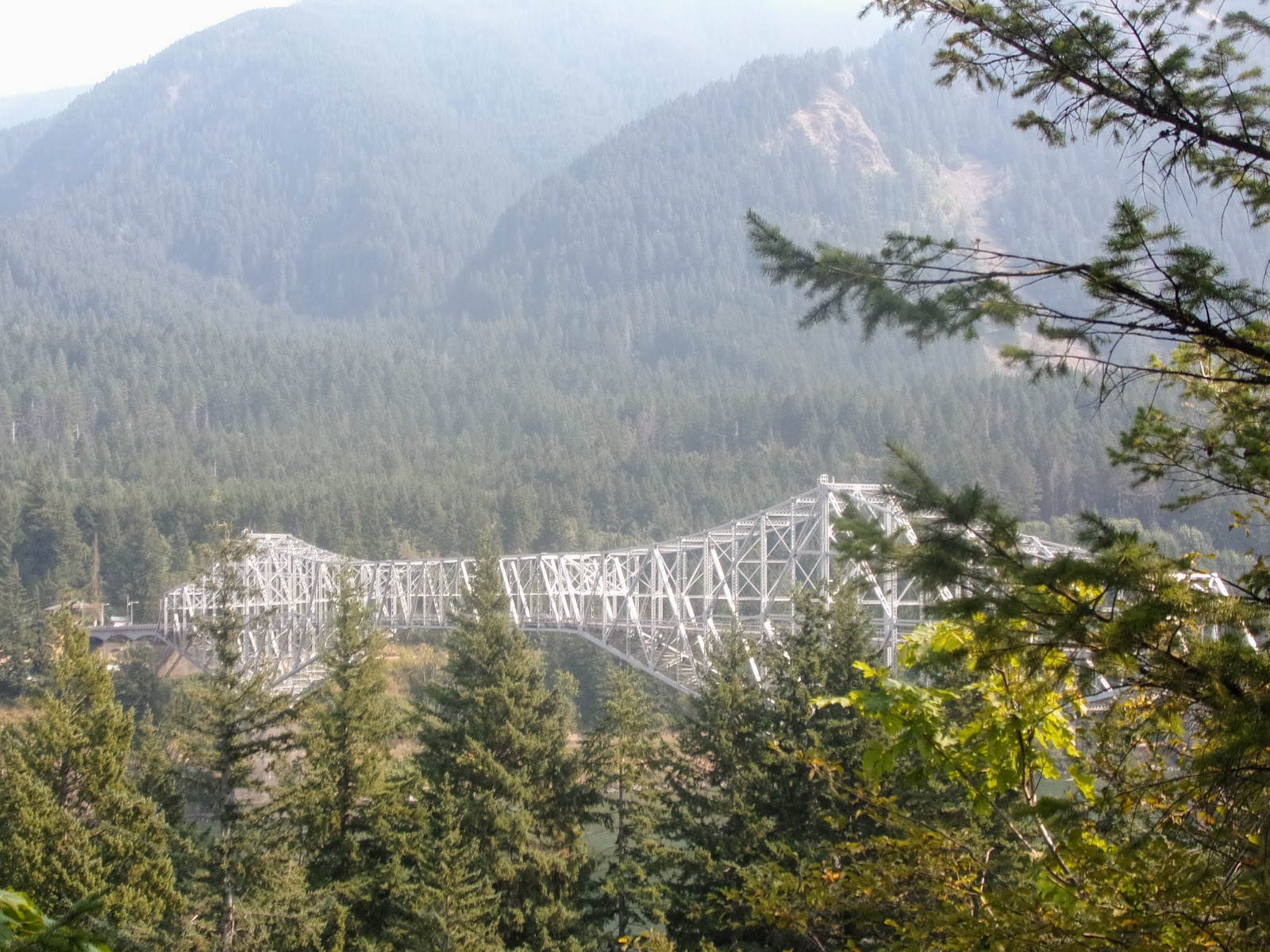
The Bridge of the Gods, as seen from the Washington side of the river.
Cascade Locks is not a big place, but has the best selection of useful stuff I've seen in a long time, there's a good store, a laundromat, and oh wow a hair salon, I can stop looking like a hobo!  I even find a scanner at one of the motels and get my Canada form sent off - still not sure it'll work mind you.  In fact, I like this place enough I decide to take a longer than usual break, fully two and a half days, well why not.

Looking towards Cascade Locks from the bridge.
I spend much of that time eating masses of cheap food, cookies, peanut butter sandwiches and the like, then some convivial evenings drinking cheap store beer at the campsite.  Lego, who I first met around fifty miles into the trail, is here, doing his normal thing of working for a few days to earn the money to get back to hiking.  For something to do, I cross the bridge, for which I have to pay a dollar - this massive construction, high above the waters of the Columbia, which I can see through the open lattice below my feet as a strong wind tries to blow me over the side, would have scared me witless once.  There's a good view here though, interesting place this, apparently an ancient rockslide from the nearby mountains once dammed the river, forming a natural bridge, which in turn was swept away following am earthquake centuries later.  On the Washington side, I walk to another small town, Stevenson, just three miles of highway from the bridge, turns out to be not much of a place, has a good store though, and I find a nice walk back along a footpath.  It really is very hiker friendly here, two of the bars give me a free beer, the third has beer for $2.75, the cheapest in US I've found I believe - plus dinner of tacos and cherry pie for a whole five dollars, it's actually quite hard to spend money here.

One of the iconic PCT locations.
While in Cascade Locks I hear the sad news, that my Gran has passed away - I remember thinking when I first started the world travel thing that one downside would be that I might not get to see her before she died, but I went anyway, now I wonder if it was right.  She was a lovely lady, part of many fond memories, and always took an interest in what I was up to.  Walking near the bridge I find a small heart, a bit of jewellery I think, I will bring it back to England to take to the cemetery, not much of a souvenir for her but I guess it is the thought that counts.

Photos to go with this post can be found here.

Pacific Crest Trail : Detroit to Cascade Locks

Miles this section : 136
Miles completed : 2144

Back on the trail.
I like Detroit, and decide to take a day off here - I can do this now, having made it to the eclipse I'm just not in a hurry any more!  The state campground people create a hiker camping section for me, so I can have a shower, then into town for my normal fare of burrito, burger and of course beer.  It's still twenty-three road miles back to the trail, along a minor road though, so easy enough even with some four thousand feet of climb.  I meet a couple of other hikers on the road, good to know it is not just me walking it.  One of them, DK, is meeting her parents later, they were here for the eclipse, in the event they drive past me and stop to give me food - I'm never too proud to accept food these days.

Timothy Lake.
It is nice to be back on the trail, it's a bit of a green tunnel here though, with not much for views, I missed Mount Jefferson doing the detour it seems.  I'm feeling a bit down, tired, my pack seems heavy even though it isn't, all the long miles to get to the eclipse catching up with me I guess.  I walk past my namesake Timothy Lake, it's a big one, good to see - there really are a lot of lakes in Oregon.  Also mountains, a large and very pointy one is now visible to the north, that will be Mount Hood.  Funny to be doing short - well, twenty-four miles or so - days now, finishing at 6pm feels weird.

Mount Hood.
Here's something to cheer me up, food - the legendary Timberline Lodge lunch buffet, I sit and eat for two hours, salad, cheese, good ham, fresh bread, proper food!  There is meat and actual veggies, proper hearty chilli, oh and so many desserts.  A pity I then waste an hour trying to sort out my Canada entry form (a bureaucratic requirement I need to complete before entering Canada via the trail).  It seems to work, but the scanned pages never reach me?  It adds up to four hours at the lodge, still I manage twenty miles in the day, less than forty left of Oregon now.

The Columbia River, Cascade Locks on the
near side, Stevenson, Washington on the far side
Still, that twenty miles was less than planned, so now I have a long day, including half an hour of walking the wrong way, oops.  There's more smoke in the air, the trail is open, though I pass campsites that are shut.  Mount Hood disappears behind me, and I can see Mount Adams in Washington - over forty miles away - ahead from a high viewpoint, before the trail plunges downhill, way downhill into the Columbia River gorge - the river crossing, via the famous Bridge of the Gods, is at around three hundred feet - the lowest point of trail.  The nearby town is called Cascade Locks, it seems very nice, hiker camping is a mere three dollars, and I find a burrito for lunch, sorted.

Photos to go with this post can be found here.

Wednesday, 30 August 2017

Pacific Crest Trail : Elk Lake to Detroit

Miles this section : 58
Miles completed : 2008

Glorious walking in the Three Sisters Wilderness.
Elk lake isn't much of a place, basically a bar and campsite next to the eponymous lake.  The store has beer, candy, and not a lot else, but no matter, my box of food, some good stuff from the hiker box, plus a pound of cheese bought from kitchen, will keep me going.  The bar has a printout of the website regarding the fires, though no actual web access.  Seems there's a thirty mile detour from here to the east, to the small town of Sisters, but from there the site says no good detour exists around the bigger closure to the north.  The fact is though, Americans simply cannot handle the idea of walking on highways, which if need be I will do - in fact I have a week-old copy of the PCT water report, which has details of a detour which is basically 'walk the highway'.  So, looks like around one hundred and seventeen miles of detour, missing eighty-seven miles of trail, I can handle that, getting back to the trail in time for the eclipse is not really feasible though.  But in fact, the detour crosses the line of maximum totality around the settlement of Detroit (Oregon, not Michigan) so my plan now is to be there.

I eat a second burger at Elk Lake, for lunch, plus an unfeasible amount of sweet potato fries.  Pocket Rocket, a Swiss hiker I've seen several times before, is here, and I ran into Vampire Hunter (from Holland) last night, nice to see familiar faces. I can't stay longer though, it's Detroit or bust, so, five road miles, no problem with that, then a steep 'climbers trail', hot work and my pack feels very heavy, but I can cope.  Then some glorious walking, with fine views of the Sisters mountains (there are, I gather, three of them), and beautiful glacial lakes, I rather like this detour.

Plume of smoke from the Milli Fire.
There are a lot of day hikers about, so many that when, late in the day, I pass through the Green Lakes area, all the 'designated campsites' are full, so I have to keep walking and of course camp just past the area boundary.  Next morning I see signs on the detour saying to go even further east, it soon becomes clear why, as a massive smoke plume from a nearby fire fills the sky on my left.  Slow moving planes drone overhead carrying water to the fire, as I walk a minor road towards Sisters, then cut north on roads that may be closed, I'm not entirely sure.  Lots of cars pass me with lights flashing, some from the fire service and at least one sheriff, they all ignore me, then as I come to the last half mile of my route towards the highway, I meet some English guys on an exchange program, with the local police I guess, they say I have to go northeast to the highway.  OK fine, I get there, some fire service guys are stopping traffic, the highway is closed to the east it seems, but yes, I can walk gravel roads to the north, they also give me a gatorade, and even let me walk half a mile east to join my planned route.  From there I head north and put a few more miles between me and the fire before camping.

Red sunset.
There seems to be less smoke next day, and anyway I'm walking away from the fire, northwest, my GPS map shows lots of roads this way, and I should be able to get back to the trail around fifteen miles north of the highway.  In the event this works well, I get through the private community (complete with golf course) without incurring the threatened one thousand dollar fine, and then find a mile or two of road made impassable by fallen trees, necessitating a bit of bushwhacking, otherwise it's all cool.  I rejoin the PCT near the Big Lake youth camp, there are forest rangers here, stopping people going south but I am OK to go north, and it is very good to be back on the trail - for a whole four miles...  After that I reach another highway, 20, I'm expecting to walk it, but no, the trail is open for nine more miles or so, then a detour will take me west, and then the it will be the highway to Detroit.  The last bit of PCT for a while is a stiff climb, but worth it for a campsite with views of an amazing red sunset over smoky mountains.  Lots of people are up here, ready for the eclipse, I wonder if I should stay?  But I don't really want to hang around for a whole day, and I do need to get on anyway.

Total eclipse!
There's not much PCT left to walk the next morning, I meet another ranger at the Minto Pass trail junction, off to the west I go.  There are a lot of deadfall trees for the first mile or so, then it's easy downhill, and then thirteen miles of Highway 22, simple if dull walking with a wide gravel shoulder - marked by hiker footprints.  Most will be hitching I know, the average hiker seems to really hate road walking, don't understand the problem myself.  I make camp in the woods by the road, having passed a campground or two which were full of eclipse watchers - and indeed wanted fifteen dollars for essentially, also, camping in the woods.

Just a few miles more and I'm in Detroit, a nice little town whose main attraction is a lake, as seems common in this part of Oregon.  I get some breakfast, then hike around the lake for half a mile or so to watch the moon pass in front of the sun, it's so smoky I can't see the other side of the lake, but the sun shines through without a problem, and unlike the last time I tried to watch an eclipse there are no clouds!  I'm prepared with eclipse glasses from trail magic, and wear them as the sun shrinks down to a crescent, this is pretty weird, though all still looks normal with the glasses off.  Then all of a sudden I'm in near darkness, looking at the amazing diamond ring effect, I then spend two minutes or so gawping at the corona, and then it's done.  Totally worth two thousand miles of walking.

Photos to go with this post can be found here and here.

Pacific Crest Trail : Mazama Village to Elk Lake

Miles this section : 132
Miles completed : 1950

Much info regarding many fires.
I'm due a zero, after seven long days of walking, and Mazama Village seems a good place for it, I'm able to do my usual wash of clothes and self, and write a bunch of messages that I can't send yet as there's no WiFi or 'cell signal'.  Rumours abound regarding the trail closures - currently the only way north is a twenty-six mile road walk around the east side of the lake, not ideal, US drivers can't handle pedestrians, I stop for them, and often they then slow to a crawl, this makes walking roads with traffic somewhat annoying.  And then an announcement - the west rim trail is open again!  This is not the official PCT, that is still shut, but everybody says the rim trail is the best route anyway.  I celebrate with a giant pizza, some beer, and then make a fire at hiker camping - not sure the other campers approve...

Majestic Crater Lake.
The rim trail really is awesome, with superb views out over the massive circular lake, it's a volcanic caldera of course, and even has a cinder cone island poking above the surface.  I can also see north to more of the Cascades, the second big mountain range of the trail, and very pointy they are too.  Off to the west there's some smoke but really not much, I doubt the PCT is that bad, rather I think the authorities err on side of caution with the closures - pretty sure this trail is only open due to the 'rim run', a marathon race that took place on the nearby road earlier this morning.  I camp just beyond the Crater Lake park boundary, so as to have no worries about camping restrictions of which there are many within the park.

Scenic Oregon.
I'm doing twenty-seven mile days, easy enough in Oregon, even through the Cascades which I've actually been in since Mount Lassen - while the mountains are impressively steep sided, the trail takes a gentle enough route between them.  Indeed, I pass a marker for the high point of the trail in both Oregon and Washington, just 7,500 feet or so - all downhill from now on!  The route includes some nice ridge walking, with views of jagged peaks, many lakes, and valleys to the west filled with smoke.  I even cross some snow on the trail, no problem though, and then downhill to walk among the lakes, of all sizes down to what are basically ponds - this means many mosquitos of course.  The new hat plus DEET keep me sane, more or less.

So many lakes.
I see signs saying the trail is closed north of Elk Lake, my next resupply point, and start to find that trails leading off west are taped off, more fire it seems, hopefully it'll work out.  SOBOs (southbound hikers) tell me of great trail magic ahead, so I walk fast, twenty-three miles by half past four, it is well worth it as Sparkle and Hannah have burgers, cookies and beer.  All goes a bit wrong five miles later at camp though, my tent zip fastener is broken, I try to fix it with my teeth, which has worked before, but no good, it is getting dark and I really need to be able to close the tent against cold air and bugs.  In some desperation I cut one of the many fasteners off my pack, and thank goodness it works!  From here it's an easy twenty-three miles down to Elk Lake, where I obtain more burger and beer, and pick up my box with masses of food, and pair of boots number four - the current pair are still in good shape, into the hiker box with them.

Photos to go with this post can be found here.

Monday, 28 August 2017

Pacific Crest Trail : Callahan's to Mazama Village

Miles this section : 102
Miles completed : 1818

There would be some tricky bouldering here were it not for the path.
Callahan's hiker breakfast comes with eggs, bacon - and pancakes!  Has the challenge put me off them?  Well, the first three go down OK, as do the second three - could probably handle more, but I do have to walk.  The plan here was a long twenty-six mile day to another resort, I can see what I was thinking but it just isn't possible what with leaving Callahan's at 9:30... and indeed, according to the trail notes the other place shuts at 5pm!  So, more Oregon then, easy walking, not much to see, a flat or slightly sloping path through woods, here and there some variation in the form of fields of big boulders, with a path made of red volcanic gravel, interesting, but sadly these sections are home to many mosquitos - all of whom really want to get into my ears for some reason.  With the new state comes new weather, it actually rains - three days in a row, after clear morning skies it clouds over and thunder rolls around, twice I just catch the edge of the storm, then on the third day it's raining as I put up the tent, and I wear my waterproof top as rain protection for the first time on the trail.  Walking through the woods after rain is very pleasant, reminds me of home, I must say I am liking Oregon.

Time to leave the trail.
I walk nearly twenty-eight miles on the second day out of Callahan's, Oregon is that easy - finishing before 7pm, my only worry a water pump I'd been planning to refill from turning out to be missing its handle.  It's a great relief to find a cache of trail magic, with water, the alternative had been a nearby muddy puddle.

A bit of road walking makes a nice change if you ask me.
My rapid pace gets me to Highway 140 quickly, this is the last road before the trail closure thirty miles or so north - walking round on the highways is an option, but I reckon I can keep going, and take the unpromisingly named 'seven mile marsh trail', then some roads to avoid the closure.  And in fact, a note taped to a post by the highway advises exactly that, so, onwards to that camp in the rain, over twenty-nine miles in one day, after which I sleep well despite the crash of thunder and flickering lightning.  From here it's more easy walking, the marsh trail is nice - and less than two miles - then road to Mazama Village, in Crater Lake National Park, but no sign of smoke, rather a lovely little resort.  All my Walmart boxes are here, with that and some choice hiker box pickings I have masses of food, and of course there is beer and burger to be had, I think I have earned it!

Annie Creek Canyon, visible on the other side are 'fossil fumaroles'.

Photos to go with this post can be found here and here.

Monday, 7 August 2017

Pacific Crest Trail : Seiad Valley to Callahan's

Miles this section : 63
Miles completed : 1716

Those infamous pancakes.
Seiad Valley is of course home to the 'infamous pancake challenge' as the sign has it, well, I will probably never be here again, it has to be done.  Five massive one pound pancakes, in a single huge pile, duly turn up - so much dough on one plate.  The first goes down pretty fast, but then halfway through the second I start to feel really quite uncomfortably full, the things are expanding inside me... I don't even manage to finish the second, I suspect carrying on would have led to me being sick...  As it is I take two away wrapped in clingfilm, they go in the outdoor hiker fridge (I approve of this idea), I go to lie down and groan.  Nice to have a day of not doing much anyway... I read a bit, order a new hat - and food this time - from Walmart, and eventually recover enough for another burrito, plus most of the chocolate from my resupply box, it'll only melt if I try to take it on the trail.


Horsing about.
No pancakes next morning, and in fact I have to wait a bit for my sausage (actually more like pork burgers) and eggs - the griddle is taken up by two guys doing the challenge, so selfish.  So it is nearly 10am when I set off, on the plus side I'm reverting to the original plan for this section, just twenty miles to do.  But... it is in fact one of the toughest ascents of the whole trail, some six thousand feet out of the valley and in a heat wave too, well, no help for it.  At least there is some cloud cover, and indeed the smoke from nearby wildfires blocks some sunlight too, nonetheless sweat pours from me as I push up the hill.  In fact, fires are casting a pall, both literally and figuratively, over the trail - news from further north is some trail sections are closed due to heavy smoke.  Where I am, the air is clear enough at my high altitude, but the surrounding landscape is hidden beneath a grey-brown blanket that stretches to the horizon.

A sea of smoke.
My second day out of Seiad is short again, a mere twenty-one miles, but while I walk quickly enough I feel pretty tired, still recovering from the pancakes I think... I pass a bit of a milestone anyway, after nearly one thousand seven hundred miles I finally leave California, hello state number two, Oregon.  I camp just over the border, and get more bad news - the trail is now closed in Crater Lake National Park, highlight of the state.  Lots of road walking coming it seems, but not just yet, instead an introduction to Oregon, gentler country it seems, rolling hills, for all their seven thousand foot altitude, cows (complete with cowbells) graze among the wild flowers, all very pleasant.  Makes for easy walking, I do the twenty-four miles by 5pm, and get a warm welcome at Callahan's Lodge alongside Interstate 5.  Beer!  All you can eat spaghetti!  All good, they even let me use their phone to call my next resupply stop, which is right next to Crater Lake.  But yes, they are open, it is not that smoky, they will take my stuff from Walmart even if it is four huge, mostly empty boxes.  Just have to figure out how to get there now...

Pretty Oregon.
Photos to go with this post can be found here.