Friday, 25 March 2016

Te Araroa : Colac Bay to Bluff

KM this section : 80
KM completed : 2997

Baby seal on Oreti Beach.
So, the last leg.  After getting through the last, long section on schedule, I'm no longer pressed for time.  First day out of Colac Bay is just thirteen kilometres, along beach (good to walk by the sea again) and some easy forest track.  With the short distance and little weight on my back, other than a few cans of beer, this doesn't feel like a long distance trail at all.  Fun though, as is another evening relaxing with a big log fire, I could get used to this.

The beach walking continues, Oreti Beach takes me most of the way to Invercargill, and after an initial shingle section I walk on sand, it's very like Ninety Mile Beach four months ago, the trail ends as it began.  Ahead of me, the hilly near-island of Bluff draws ever closer.  First though, Invercargill, a busy port city, seems like a good place to come for sheet metal.  Not so good for beer, supermarkets are not allowed to sell it, and I end up traipsing to an outskirts of town 'super liquor store'.  Because obviously forcing people to drive out and buy booze in bulk is a smart policy...

Homing in on Bluff.
The last day... a nice walk through wetlands along a cycle trail that one day will extend to Bluff.  I have to clamber over a fence at one point to access a weather damaged bridge, seems fine to me, though I wouldn't fancy cycling the embankment on the other side which is under repair.  Then the track ends and I walk the highway for fifteen kilometres or so, not really a problem.  The last hour or two is a circle around Bluff, firstly through bleak and windswept coastal grassland, and then a well built path through scrub.  I find myself slowing, not from fatigue but rather to draw out the moment.  Can it really be about to end?  Well, it is an anticlimax of course, there is not even any TA sign or monument at the end.  I guess this old whaling station, most southerly town in South Island, settled before NZ was a colony, has been a tourist destination long before the TA has existed.

And that's it... I will write a retrospective at some point, maybe when I have a real keyboard.  For now, time for a rest, I'm in pretty good shape but am so looking forward to just not doing much for a few days.  Oh, one more thing - those fifty dollar Warehouse boots?  Still going after some nine hundred kilometres.

Totally made it the whole way, oh yes.

Photos to go with this post can be found here.

Wednesday, 16 March 2016

Te Araroa : Ohai to Colac Bay

KM this section : 88
KM completed : 2917

About time I read some of this.
I've been a bit uncertain about the next bit, the guide has a total of thirty-three and a half hours to Colac Bay, there are lots of warnings about 'no camping', and just one hut.  My original plan calls for three days, the second being thirteen and a half hours to get me to that hut, well let's see.  In the event what I get is a demonstration of the DOC's undue deference to private landowners, hence all the 'no camping', there are also many signs warning to only tramp in daylight hours, in groups no larger than eight, etc.  There is even a section of pine forest that we are supposed to phone the owner and ask permission before entering, presumably tugging on our forelocks while doing so...

Signal masts on Bald Hill.
The walking?  First day turns out to be mostly road or gravel farm track so I rip the guide estimated time apart, end up camped just into a wood, some three hours ahead of plan.  Gravel tracks continue through the forest and up to an array of signal masts on Bald Hill, from here I can see the sea, and oh my that is Bluff, endpoint of the trail, at the end of the bay there.  Can also see Stewart Island, no I'm not going there, the trail stops at Bluff and so will I.  What can the TA throw at me first?  Well, the route down to Martin's Hut is through bog, and some of the worst, muddiest, most horrible forest I've seen for a while, and it's raining.  But so what, it's nearly the end.

You can see Bluff from here!
The tiny four bunk hut is a squeeze for me, Dragos and French Tim, plus Germans Carl and Jonas, but at least that keeps it warm.  I feel rather guilty about poor Kiwi Bob who arrives late and camps outside, he seems OK though.  This is the last hut, feels weird to leave it.  But I have more awful mud to wade through... today the route is along a water race from the old gold mining days, at least it follows a contour line, but of course has not been maintained as a path since the miners left in 1920 or whatever.  At regular intervals I clamber over trees, down into eroded ravines, all with the rain coming down... on at least two occasions I slip into deep holes or the old race itself, neither this, nor banging my head against trees repeatedly, is much fun.  Believe it or not, the DOC has the gall to suggest any TA thru-hiker should give them a (quite substantial) cash donation in return for hiking the trail.  Well it is while walking this 'path' that I finally decide they're not getting a cent from me.  Seems that in any case their priority is to provide huts for their rangers to stay in while out on 'conservation', i.e. hunting, trips...

For all that, I make good time to Colac Bay, where there is, oh yes, a pub.  Also does camping, that is me set for a day or two, doing that last bit in three days means I have time to spare.  I buy a burger and much beer... so nice to have a day of not walking, though after a lie in, cleaning of self and clothes, what shall I do in the afternoon?  Oh, there is a big wood burning stove that I can sit feeding logs to you say?  Go on then :)

Back in the woods.  But not for long :)
Photos to go with this post can be found here.

Tuesday, 15 March 2016

Te Araroa : Mavora Lakes to Ohai

KM this section : 109
KM completed : 2831

Is it too high?
Hard to believe there are only ten days or so of walking left... when the going is hard I tell myself, 'not long to go', but really I am going to miss this.  Well, not there yet... indeed there is another Mavora Lake, the south one if anything more beautiful than the north.  Then I walk along the Mavora river, the couples said something about taking the road rather than a terrible river trail, surely not this though, it's a lovely walk.  Then I reach a bit of DOC idiocy, a sign says 'don't stay on this path if the river is high, cross here (there is a bridge) and follow the left bank instead'.  Is the river 'high'?  I don't think so... across the bridge, there is no path on the left bank... well I stay on the path, which is good, but that's because it's part of a loop track back to the lake, whereas I have to ford the river.  Well that is easy enough, it is indeed not high... but sadly, clearly pretty much every TA walker has taken the road, all I find on the far bank are pole markers, too far apart to even guess at a path.  I struggle on, but hacking along through bog, over fences and so forth is not much fun, this is the terrible river trail I guess.  In the end I give up and make my way to the road.

The Aparima River.
Well, makes for easier walking, though I briefly revisit the 'trail', to camp on it.  Much further ahead than planned too, this is in a section that the guide helpfully suggests two to three days for, well, turns out to mean around fifteen hours as per signs on the ground, less in fact when I come to walking it.  Does seem to be a thing that the oh-so-macho 'I don't need a path, I'll just walk down the river' DOC people nonetheless think five hours is a fair day's walking.  But anyway... what the guide gives with one hand, it takes away with the other, the next section, five hours in the guide, is signed as eight on the ground :(  I make it six and a half hours of hard slog through forest, am glad to reach a hut, get a fire going and relax.

On Telford Tops.
And then, a good day again... more forest, but easy enough, much of it the mossy high altitude woodland.  Then open hills, well, at just over one thousand metres I guess Telford Tops includes a mountain... the last time I'll climb one here maybe?  And then a nice walk down a ridge line to camp.  I've made good time, some 4 hours ahead of plan now, this is good as I can get to Ohai early.  And so it proves, after a nice day of walking over farm tracks I get to town, what there is of it, Ohai, an old coal mining community, has clearly seen better days.  All the shops are shut, as is the pub in which I stay the night - they still do accommodation, nice place to stay and I manage not to be tempted by the many bottles of spirits hanging about.  For lo, my resupply box is here, I have two cans of beer and also two tins of STAG CHILLI, together with some two hundred and fifty grams dry weight of rice this makes one hell of a meal.

Bustling Ohai.
Photos to go with this post can be found here.

Saturday, 12 March 2016

Te Araroa : Queenstown to Mavora Lakes

KM this section : 52
KM completed : 2723

TSS Earnslaw.
I'm a bit dubious about Queenstown - it is very touristy indeed, and in particular caters to a young 'extreme sports' crowd, here for the canyoning (no, no idea) etc., not really my kind of place.  Still my campsite is pleasant (free wine in the fridge to complement my four cheeseburgers) and I find a bar with five dollar pints so not all bad.  And I do leave in style... this is yet another 'dead end for walkers', as we have to find a way past Lake Wakatipu, NZ's third largest lake.  I do it by taking the TSS Earnslaw, a paragon of steam technology from 1912, which makes impressive speed over the water.  Shame there aren't more such things still around, I guess the need for a stoker to constantly shovel in fuel is a problem - reminds me of my own fuel regime...

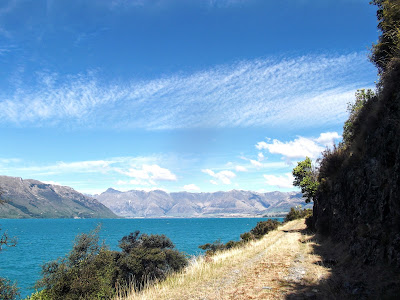
On the rather nice private path along Lake Wakatipu.
One issue, I reach the other side of the lake at 11am some thirty kilometres south of where the trail restarts.  Well no biggie, twelve kilometres of gravel road, then the map shows a track along the water's edge, this turns out to be lovely grassy walking with of course wonderful views.  It's private land, but frankly I don't really care... in the event there is a single padlocked gate en route that I climb, beyond that no problem reaching the trailhead (flush toilets!) and camping nearby.

Walking remains good up the Greenstone river, you can tell this is still 'circular walk from a base at Queenstown' territory.  But once past the obvious 'loop back' point things go downhill... not literally, I climb up over a saddle, but the path becomes hard to find, the terrain is boggy, and it is raining.  At least it is a short day, but I have to say on arrival at Taipo hut, my stop for the night, I'm feeling a little unenthusiastic.  Oh well, two couples, one French and one German, arrive, and despite the weather they have more than enough enthusiasm for us all.

I get my mojo back soon enough though, as next day the sun comes out, there is fine walking along farm tracks through the high country, and before long the North Mavora Lake comes into view, another one for the LOTR location list (Nen Hithoel for what it's worth).  Certainly a nice place to camp... not totally loving the way that next morning, the condensation inside my tent flysheet has actually frozen, still, wonderful to see the mist rising from the lake as the sun crests the surrounding hills.

North Mavora Lake.
Photos to go with this post can be found here.

Saturday, 5 March 2016

Te Araroa : Albert Town to Queenstown

KM this section : 103
KM completed : 2671

On the trail around Lake Wanaka - I love that hiker-shaped tree.
From Albert Town it is a short walk to Wanaka, on the side of the lake that shares its name.  Seems like a nice place, plenty of bars, I wish I could stay... I do hang around long enough to do some shopping and actually send a food parcel, my first - well, it is a ten day stretch out of Queenstown without any shops, so having this box of food waiting for me at a lodge along the way will be good.

I walk around Lake Wanaka for some time, easy going on a cycle track, easy enough that there are lots of people here.  It can't last though, the last five kilometres of the day being a tough climb up to Fern Burn Hut.  Wow, a modern hut, I actually use one of the passes I've been carrying as this one is not free.  A couple of guys here, doing things rather differently to me - one has a huge amount of food, including tins, fresh fruit and veg (I have enough for one more night, and two days, so not much).  The other has big paper books, including a hardbound A4 pad he is using for writing...

Not quite so flat up here.
The hard walking continues, this is bleak upland country and the way is along stony ridges or up and down steep slopes, bare but for grassy tussocks.  The verdant forests of North Island seem a long way away (good!).  Plan is for just seventeen kilometres today, but... maybe a year or two ago it would have been pretty bad here, but now a steady stream of trampers have beaten out a walkable path, and I reach my planned stop at not long after 5pm.  Too early to stop, so I make it up and over yet another saddle to camp next to the Arrow river.

Restored cottage in Macetown.
Turns out this was a good thing to do.  The guide has four hours from the hut to Macetown, an abandoned mining town now inhabited only by sandflies.  You can see the old spoil heaps all around, and a couple of restored stone buildings... and it took a little over four hours.  Then the guide has another four hours to Arrowtown - which I really don't think is possible.  It's a nice walk, up to a saddle again, then down a well graded path, very well travelled, you can tell Queenstown is near.  At the saddle is a sign reading 'Arrowtown 2 hours - Macetown 2 hours' - that doesn't mean it is four from one to the other guys...  OK, last stretch is easy cycle track, but even here the guide estimate is very sketchy, five and a half hours for nearly thirty kilometres?  Good thing I am only going as far as Frankton today, a nice little suburb where I camp and eat massive pizza.  Then just seven kilometres to the centre next day, that counts as a day off.

Saddle between Macetown and Arrowtown.
Photos to go with this post can be found here.

Te Araroa : Twizel to Albert Town

KM this section : 129
KM completed : 2568

The horsey hut.
I spend a pleasant day walking out of Twizel, alongside a few of the many lakes boasted by this region, makes for easy, flat walking and fine views.  Last of the day is Lake Ohau, which has a lodge beside it where I've booked dinner and camping.  But they offer me a room for just fifty-four dollars which I cannot resist, and dinner is soon served - they are hosting a wedding so a small group of trampers and cyclists get the same meal, an excellent three courses.  Then after a welcome shower (two in one day!) I head for the bar, they're happy for me to crash the wedding reception it seems.  Beer and even dancing ensues, there is a band, but I do have to be up in the morning - the nice people give me a free upgrade to a quieter part of the building.  I approve of this place.

High above Lake Hawea.
Back to walking, and back to the hard stuff, as I climb from the lodge past some ski slopes and up to a saddle, seems not to be a well walked path and there are no huts, not that I need one.  That said, an hour past my camp spot is a hut not marked on the map, apparently privately owned, I pass it next morning and a bunch of horse riders are getting ready to go (cheers for the coffee!).  Seems Transient took the last bed anyway.

It is good to walk the horse graded track for a while, but one of the horsey types reckoned this was the worst section of the trail.  Well, soon enough I leave the horse track, and yes it is crazy up and down, yes there are some river crossings, but the worst?  Half of North Island is worse than this... still, the day ends with a brutal climb and I am glad to reach a hut, good not to have to put the tent up.  No big surprise to find Transient here, and nice that he has a fire going, this is an old hut, high up and it's going to get cold.  And it sure does... I walk out next morning, and it is absolutely perishing, there is frost on the ground and I wish I had gloves, but all I can do is dash uphill and into the sweet sunlight.   This turns into a fantastic walk over high ridges and well walked paths, then a stupendous descent down a ridge line with Lake Hawea below, almost a vertical kilometre below in fact.

A little way around the lake is Hawea Township, not much of a place, but then neither is Albert Town, a little further via a nice cycle track.  Can't complain about the seven dollar campsite, nor indeed the beer and fish and chips.  Back into the hills tomorrow...

Down the vertiginous slope.
Photos to go with this post can be found here.